I took some time off in November this year to visit Skye and Raasay for a late-season holiday with my wife, Rose. Never one to travel too far without my camera, I decided to put these words and pictures together in a mini photo-journal at the end of what has been a rather magical and unforgettable experience.
Although I was too young to remember the earliest trips, I know that I have been coming to Skye regularly since I was about two years old. I think it is probably the Scottish island I have visited most, the other being Shetland, although I have definitely been coming to Skye for a good deal longer. All I seem to remember of the times when I holidayed here with my parents were the never-ending car journeys along tortuously-windy single-track roads which are now mostly all dual-carriageway. The same journey can now be made in a few hours rather than the full day I vaguely remember it used to take. For the younger me, the two great highlights of the journey were just the slim chance that I may glimpse the Loch Ness Monster from the road somewhere between Drumnadrochit and Invermoriston and the ferry journey from Kyle of Lochalsh to Kyleakin which was massively exciting. I really miss those old ferries!
My father, Michael Marshall, worked as a producer in the BBC for many years. He was great friends with the late journalist and presenter Derek Cooper who spent a great deal of his time on Skye and who also wrote the gazetteer 'Skye' - its first edition published in 1970. Although it is now out of print, I think copies can still be found here and there (https://www.amazon.co.uk/Skye-Derek-Cooper/dp/0710068204). It was in the Skye town of Portree where Derek and his wife Janet spent their holidays and I faintly remember later trips to holiday with them. Day-outings to the west and Dunvegan or up to Trotternish and the narrow and twisty roads with rusty old cattle-grids and passing places on the way out to Staffin. I seem to remember spending a bit of time up at places like Skeabost or Stein Inn, or going for lunch at the Cuillin Hotel in Portree, but probably not being allowed anywhere near the bar in those days! And I also remember making the walk to the local baker every morning except on the sabbath day of course, to collect wonderful, freshly-baked sugary doughnuts, usually accompanied by my mother or by my grandfather, Alec Marshall.
A trip that I remember nothing of, however, was over to Raasay. I only know I have been here thanks to a series of wonderful photographs taken by my father and which I greatly treasure. One of these photos shows a two-year-old Robert (Bob) Marshall, me, being carried by Malcolm (Calum) MacLeod in 1975 along a stretch of the now fabled road that bears his name and which he single-handedly constructed over a period of ten years between 1964 and 1974 with little more than a shovel, a pick and a wheelbarrow. I only came to realise the enormous scale of this man's achievement in my adult years and having read his compelling story written in 2006 by Roger Hutchinson (Birlinn. ISBN 978-1-84158-447-8). And it was around this time that my mother handed me the photograph of me being carried along the road by none other than the man himself in 1975 when I was two years old.
In 1975, my family visited Raasay as part of our holiday on Skye. At this point, Calum had completed construction of his road and the photograph shows what I am thinking must be the final few hundred metres of this leading to his croft at Arnish. The road was not surfaced with tarmac until 1982 when the council finally adopted it but by then, Calum and his wife, Lexie, were the last remaining inhabitants of Arnish. Calum died in 1988.
Since reading Roger's book, I had planned to visit Raasay to retrace my childhood footsteps and to walk the road that Calum built by hand. In November 2018, my wife Rose and I took a few days off from our busy schedule to visit Skye and Raasay for a belated summer holiday. We were astonishingly lucky to have been blessed with several days of excellent weather and I had some great opportunities to visit some fabulous castles (most of which I have visited before) and I also got to do a bit of walking too!
Rose's mother's surname is Macrae which is indigenous in the Skye and Lochalsh areas, as is the name MacLeod, and we believe that it is through Rose's grandmother's MacLeod name that, Calum MacLeod who built the road, may actually be a relation. So, Rose and I both had a shared interest in discovering more about Calum's background. She's been doing quite a lot of research in order to write a small book on her ancestry and much of our holiday was dedicated to tracing her family roots and connections which I found it extremely fascinating. It was wonderful to spend time with some of her relations and also to speak to a few local people who are extremely knowledgeable about the Macrae history and their genealogy. Our travels over these six days took us to Kintail and Eilean Donan Castle, Duirinish, Plockton, The Archives Centre at Portree, Kyle of Lochalsh and Raasay.
On the day that Rose spent in the Archives at Portree, I took a wee wander up to the Storr to enjoy perhaps one of the finest late autumn days I have experienced in recent years. With the sun out, it was pleasantly warm, but perhaps the most memorable experience was the absolute silence. There wasn't a breath of wind and it was just possible to make out the voices of people in conversation almost a kilometre away from where I was standing. The tall cliffs behind the Storr form a natural amphitheatre and amplifier making sound travel and reverberate over longer distances. This, combined with the sun casting interesting light rays through gaps in these cathedral-like rock spires, made it a rather spooky and magical spectacle.
Although this was not part of our research, we took a trip down to Glenelg to see the two iron-age brochs of Dun Telve and Dun Troddan. These remarkably-intact structures are a fascinating glimpse into the ancient lives of our distant ancestors. I've visited a few brochs around Scotland, especially those in Shetland, but the Glenelg brochs are unique in their own individual ways and this was the first time I have had a proper chance to look at them in detail.
On the same morning I paid a quick re-visit to Caisteal Maol (Castle Moil) at Kyleakin. I last visited and photographed this castle in 2015, however in February 2018, the castle was struck by a bolt of lightning which destroyed part of the top half of the Northernmost remaining wallhead causing it to collapse. The ruin has since been stabilised to make it safe. The remains of the original wallhead now spill down the northern flank of the ancient dun on which the castle is built. It was interesting to note that the ruin has now been fitted with a lightning conductor!
Our day over on Raasay started fairly early. We picked the day that had the best weather and set out to catch the early ferry from Sconser to make the most of the available daylight. It gets dark very quickly, around about 4.30pm, at this time of year and we knew we had a lot to see and do while we were on the island. Our first objective was to walk the entire length of Calum's Road. Although we had taken the car with us and could perfectly well have driven the 1¾-mile road, I simply could never have lived with myself not having paid proper homage to Calum by driving it! I had to walk along his road in order to ponder on and savour his monumental effort - ten years of back-breaking labour.
Our starting off point for the walk was Brochel. This is the site of a rather magnificent castle of the same name. What is left of this now ruinous late 15th/early 16th century stronghold clings perilously to a tall stack-like volcanic plug of rock. It is in a highly-dangerous state of disrepair and fenced off for obvious safety reasons. I decided that it would be for the best to take heed of the various notices posted around about the foot of the castle warning of falling masonry and imminent collapse. The entrance to the castle was originally on the eastern, seaward side of the castle. It doesn't look like it would be terribly difficult for an able-bodied man like me to scramble up and access the castle, but I don't think it would be wise to take the risk, nor indeed the chance that I may cause further damage to this fabulous ruin in attempting to access it. I much prefer to observe from a respectfully safe distance!
Brochel is located in a wonderful spot close to the beach affording fantastic views over the Sound of Raasay to the Applecross Peninsula. It is easy to understand why a castle was built here by Raasay's first Macleod chief, Calum Garbh or (later) Calum MacGilleChaluim, and afterwards occupied by the Macsweens.
At Brochel begins the start of Calum's Road. Around almost every bend, kink, rise and dip in the road, there are indications that this marvel of road-building was no easy feat. Even for modern machinery, I would expect it would have presented quite a reasonable engineering challenge. That Calum managed to build this all this on his own, and the fact that later workmen had very little, if any remedial work to do to prepare this road for its tarmac surface is truly awe-inspiring.
Our journey along the road that Calum built was made all the more special with the chance to meet with Calum's surviving daughter, Julia, who just happened to be staying at Arnish at the same weekend that we were visiting. It was a truly wonderful encounter and the chance for Rose to make a connection with the MacLeod side of her family.
With thanks to my father for the use of the photos of Calum's Road and Arnish, 1975 and also to my lovely wife, Rose, for taking some of the photos of me and for being such fantastic company for the six days we spent up here.
All photos © Bob, Rose and Michael Marshall 1975 & 2018
https://www.undiscoveredscotland.co.uk/raasay/calumsroad/index.html
Roger Hutchinson's book - https://www.amazon.co.uk/Calums-Road-Roger-Hutchinson/dp/1841586773/ref=tmm_pap_swatch_0?_encoding=UTF8&qid=&sr=
Brochel Castle
https://canmore.org.uk/site/11504/raasay-brochel-castle
http://www.isleofraasay.com/index.php/2016/11/05/brochel-castle/
Dun Telve and Dun Troddan Brochs
https://www.historicenvironment.scot/visit-a-place/places/glenelg-brochs-dun-telve-and-dun-troddan/
Caisteal Maol
https://canmore.org.uk/site/11663/skye-kyleakin-caisteal-maol
Eilean Donan Castle
https://www.undiscoveredscotland.co.uk/dornie/eileandonancastle/index.html
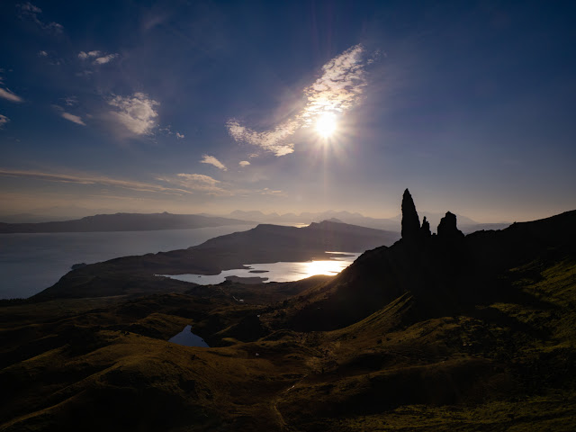 |
The Storr, Isle of Skye
|
My father, Michael Marshall, worked as a producer in the BBC for many years. He was great friends with the late journalist and presenter Derek Cooper who spent a great deal of his time on Skye and who also wrote the gazetteer 'Skye' - its first edition published in 1970. Although it is now out of print, I think copies can still be found here and there (https://www.amazon.co.uk/Skye-Derek-Cooper/dp/0710068204). It was in the Skye town of Portree where Derek and his wife Janet spent their holidays and I faintly remember later trips to holiday with them. Day-outings to the west and Dunvegan or up to Trotternish and the narrow and twisty roads with rusty old cattle-grids and passing places on the way out to Staffin. I seem to remember spending a bit of time up at places like Skeabost or Stein Inn, or going for lunch at the Cuillin Hotel in Portree, but probably not being allowed anywhere near the bar in those days! And I also remember making the walk to the local baker every morning except on the sabbath day of course, to collect wonderful, freshly-baked sugary doughnuts, usually accompanied by my mother or by my grandfather, Alec Marshall.
A trip that I remember nothing of, however, was over to Raasay. I only know I have been here thanks to a series of wonderful photographs taken by my father and which I greatly treasure. One of these photos shows a two-year-old Robert (Bob) Marshall, me, being carried by Malcolm (Calum) MacLeod in 1975 along a stretch of the now fabled road that bears his name and which he single-handedly constructed over a period of ten years between 1964 and 1974 with little more than a shovel, a pick and a wheelbarrow. I only came to realise the enormous scale of this man's achievement in my adult years and having read his compelling story written in 2006 by Roger Hutchinson (Birlinn. ISBN 978-1-84158-447-8). And it was around this time that my mother handed me the photograph of me being carried along the road by none other than the man himself in 1975 when I was two years old.
 |
Left: Calum MacLeod holding the young Robert (Bob) Marshall aged two in 1975.
Right: Bob Marshall revisits Calum's Road in 2018, 43 years later.
|
Since reading Roger's book, I had planned to visit Raasay to retrace my childhood footsteps and to walk the road that Calum built by hand. In November 2018, my wife Rose and I took a few days off from our busy schedule to visit Skye and Raasay for a belated summer holiday. We were astonishingly lucky to have been blessed with several days of excellent weather and I had some great opportunities to visit some fabulous castles (most of which I have visited before) and I also got to do a bit of walking too!
 |
Rose and Bob Marshall walking Calum's Road
|
 |
The cathedral-like spires and pinnacles of the Storr, Isle of Skye
|
 |
Low winter sun behind the Storr, Isle of Skye
|
On the day that Rose spent in the Archives at Portree, I took a wee wander up to the Storr to enjoy perhaps one of the finest late autumn days I have experienced in recent years. With the sun out, it was pleasantly warm, but perhaps the most memorable experience was the absolute silence. There wasn't a breath of wind and it was just possible to make out the voices of people in conversation almost a kilometre away from where I was standing. The tall cliffs behind the Storr form a natural amphitheatre and amplifier making sound travel and reverberate over longer distances. This, combined with the sun casting interesting light rays through gaps in these cathedral-like rock spires, made it a rather spooky and magical spectacle.
 |
Dun Telve Broch, Glenelg
|
On the same morning I paid a quick re-visit to Caisteal Maol (Castle Moil) at Kyleakin. I last visited and photographed this castle in 2015, however in February 2018, the castle was struck by a bolt of lightning which destroyed part of the top half of the Northernmost remaining wallhead causing it to collapse. The ruin has since been stabilised to make it safe. The remains of the original wallhead now spill down the northern flank of the ancient dun on which the castle is built. It was interesting to note that the ruin has now been fitted with a lightning conductor!
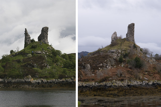 |
Left: Caisteal Maol, Kyleakin, Skye (2015). Right: Caisteal Maol, Kyleakin, Skye (2018) showing the extent of the damage caused by a lightning storm in February 2018.
|
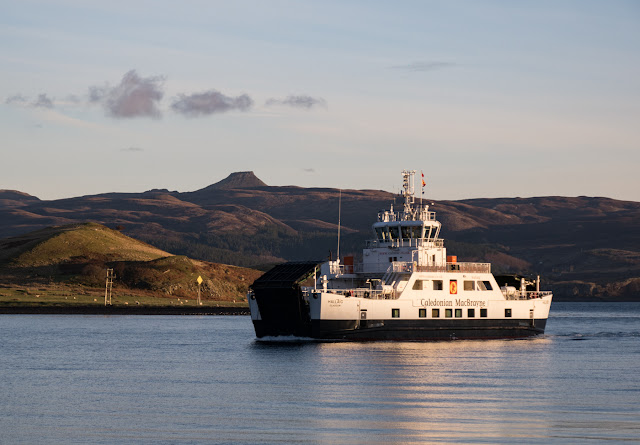 |
Ferry from Sconser to Raasay (operated by Caledonian MacBrayne)
|
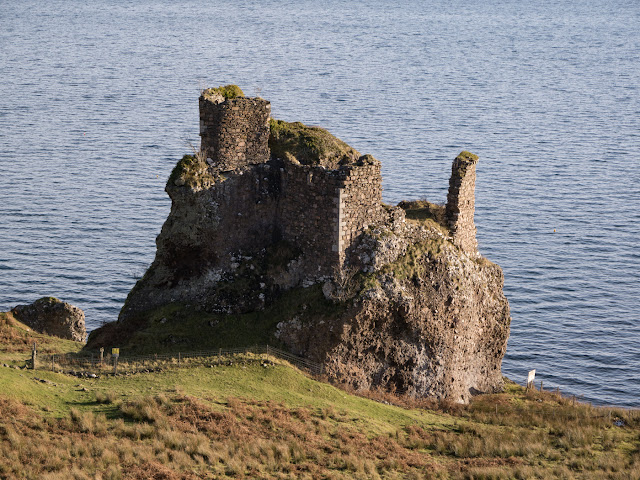 |
Brochel Castle
|
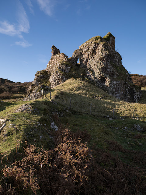 |
Brochel Castle (entrance to the east)
|
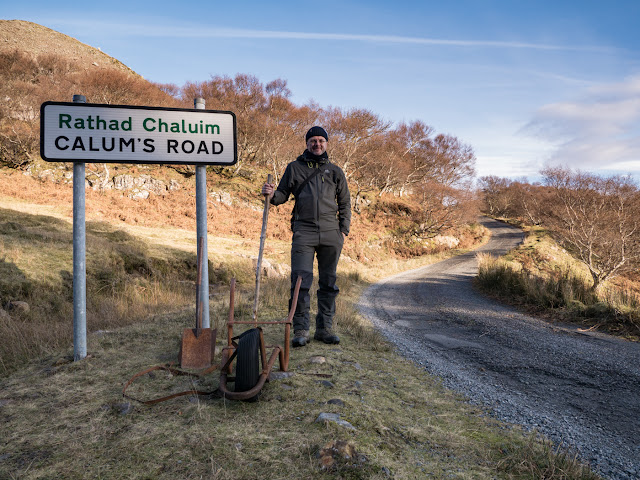 |
The start of Calum's Road at Brochel
|
At Brochel begins the start of Calum's Road. Around almost every bend, kink, rise and dip in the road, there are indications that this marvel of road-building was no easy feat. Even for modern machinery, I would expect it would have presented quite a reasonable engineering challenge. That Calum managed to build this all this on his own, and the fact that later workmen had very little, if any remedial work to do to prepare this road for its tarmac surface is truly awe-inspiring.
Our journey along the road that Calum built was made all the more special with the chance to meet with Calum's surviving daughter, Julia, who just happened to be staying at Arnish at the same weekend that we were visiting. It was a truly wonderful encounter and the chance for Rose to make a connection with the MacLeod side of her family.
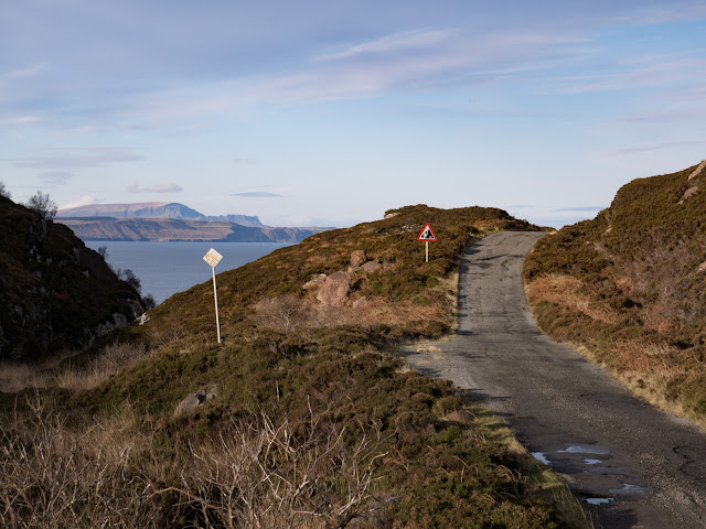 |
Calum's Road - view looking North towards Staffin in the distance
|
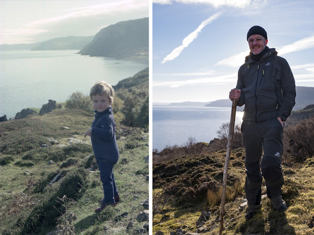 |
Left: Young Robert (Bob) Marshall on Calum's Road at Brochel 1975.
Right: Bob Marshall on Calum's Road at Brochel 2018.
|
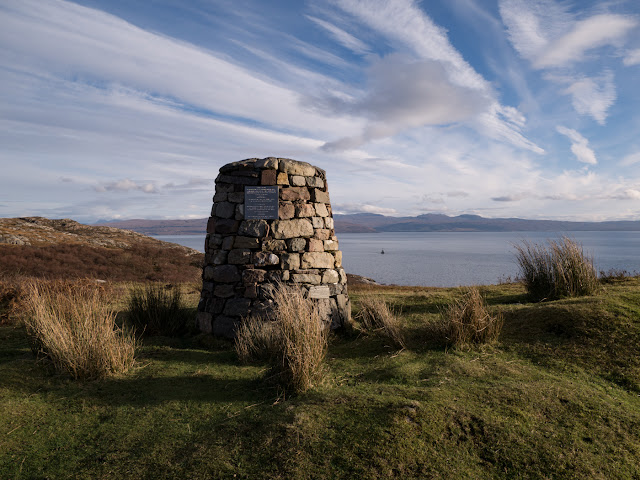 |
The cairn commemorating Calum's achievement
|
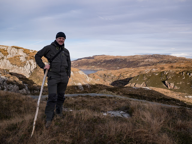 |
Standing roughly half way along Calum's Road where the road drops steeply down towards a small inlet at the head of Loch Arnish.
|
 |
My mother, our old car and me at Brochel Castle, Raasay in 1975
|
 |
Calum MacLeod and my father, Michael (carrying me) across a hayfield at Arnish Croft in 1975
|
 |
Arnish croft in 1975
|
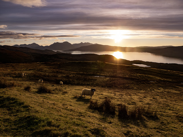 |
View from Raasay looking South-west towards the Cuillins
|
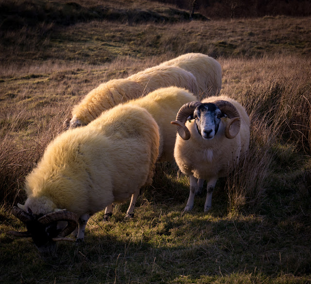 |
Sheep grazing on Raasay
|
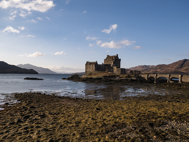 |
Eilean Donan Castle
|
All photos © Bob, Rose and Michael Marshall 1975 & 2018
Links:
Calum's Roadhttps://www.undiscoveredscotland.co.uk/raasay/calumsroad/index.html
Roger Hutchinson's book - https://www.amazon.co.uk/Calums-Road-Roger-Hutchinson/dp/1841586773/ref=tmm_pap_swatch_0?_encoding=UTF8&qid=&sr=
Brochel Castle
https://canmore.org.uk/site/11504/raasay-brochel-castle
http://www.isleofraasay.com/index.php/2016/11/05/brochel-castle/
Dun Telve and Dun Troddan Brochs
https://www.historicenvironment.scot/visit-a-place/places/glenelg-brochs-dun-telve-and-dun-troddan/
Caisteal Maol
https://canmore.org.uk/site/11663/skye-kyleakin-caisteal-maol
Eilean Donan Castle
https://www.undiscoveredscotland.co.uk/dornie/eileandonancastle/index.html


